B: A to Z History of Horsham’s Roads and Streets

17 January 2023
Street names can give us a window into a time gone by. They commemorate the people who have lived there, their livelihoods and accomplishments, as well as giving an insight into what was happening at the time.
Throughout 2023, we will be exploring the origins of some of Horsham’s road names. Throughout the journey, we hope to shed light on some of the personalities that have graced Horsham through the years, as well as sharing some of the stories of yesteryear. We have researched the stories in local libraries and archives to find the sources of these stories. If you have any anecdotes or information that you would like to add, please let us know!
Bailey Close
- Age: 1990s
- Postcode: RH12 5QR
- Length: 51 metres long
- Connected to: Meadow Farm Lane
- Nearest Schools: All Saints CofE Primary School, Holbrook Primary School, St Robert Southwell Catholic Primary School
- Nearest Rail Stations: Littlehaven Station is 0.47 miles away, Warnham Station is 1.07 miles away
No official record stands as to why Bailey Close is called Bailey, however it might have been after the motte and bailey castle that once stood close by. Chennellsbrook was built by the Normans in the 13th century, and it followed the castle design widely considered the most secure at the time. Also nearby was a moated house, built in the same era, which was owned by the Hurst family for a significant period of time.
Bartholomew Way
Postcode: RH12 5JL
Length: Approximately 682 metres long
Connected to: Tylden Way, Cissbury Close, Lanyon Close, Standen Place, Lemmington Way, Bignor Close, Oldbury Close, Shottermill
Nearest Schools: All Saints CofE Primary School, Horsham, St Robert Southwell Catholic Primary School, Horsham, Littlehaven Infant School
Nearest Rail Station: Littlehaven Station is 0.46 miles away, Warnham Station is 1.43 miles away
Bartholomew is a Jewish name, and the name of one of the twelve apostles. Bartholomew is the patron saint of tanners, tailors, plasterers, and leatherworkers. He is also associated with bookbinders, farmers, house painters, butchers, and glove makers. It was the real surname of iconic comedian Eric Morecambe.
Barttelot Road
- Age: 1893
- Postcode: RH12 1DQ and RH12 1DE
- Length: Approximately 192 metres long
- Connected to: East Street
- Nearest Schools: St Mary’s CofE Primary School, The College of Richard Collyer, Littlehaven Education Trust
- Nearest Rail Stations: Horsham Station, Littlehaven Station
Sir Walter Barttelot was the MP for West Sussex from 1860, until he became the member for Horsham in 1885. The Sussex Police Headquarters was located on Barttelot Road. John Haigh, the infamous acid bath murderer was held in the cells of this police station before he appeared in the Town Hall Magistrates.

A caricature of Sir Walter Barttelot, published in Vanity Fair in 1886.
Bennetts Road
Postcode: RH13 5JX
Length: Approximately 678 metres long
Connected to: Elm Grove, Orchard Road, Higgins Way
Nearest Schools: Littlehaven Educational Trust, The Forest School, Queen Elizabeth II Silver Jubilee School
Nearest Rail Station: Horsham Station is 0.60 miles away, Littlehaven Station is 1.46 miles away
There is an interesting grave by the entrance path in St Mary’s graveyard. Helena Bennett was a well born Indian woman who moved to St Leonards Forest after her French husband, Benot de Boigne, left her. She was known for her kindness to the poor, and Shelley wrote a poem about her. She was living in North Street when she passed away.
Ben’s Acre
Age: 1979
Postcode: RH13 6LW
Length: Approximately 347 metres
Connected to: Grebe Crescent
Nearest Schools: Heron Way Primary School, QEII Silver Jubilee School, The Forest School
Nearest Rail Stations: Horsham Station is 0.95 miles away, Littlehaven Station is 1.31 miles away
Ben’s Acre has one of the most wholesome reasons behind the name. Ben was a horse that used to graze this land, when the land was owned by Helen Davis and her parents.
Bethune Road
- Age: 1950
- Postcode: RH13 5JP and RH13 5JN
- Length: Approximately 309 metres long
- Connected to: Melksham Close, Orchard Road
- Nearest Schools: The Forest School, Millais School, Littlehaven Educational Trust
- Nearest Rail Stations: Horsham Station is 0.46 miles away, Littlehaven Station is 1.33 miles away
The Bethune Family were a notable Horsham family who were related through marriage to the enigmatic Eversfield family, who owned Denne Park. As the Eversfield family had no direct heirs, the property passed to the Bethune Family in 1903. However, the Bethune family did change their surname to Eversfield.
Bignor Close
- Postcode: RH12 5JQ
- Length: Approximately 158 metres long
- Connected to: Bartholomew Way
- Nearest Schools: All Saints CofE Primary School, St Robert Southwell Catholic Primary School, Littlehaven Infant School
- Nearest Rail Station: Littlehaven Station is 0.53 miles away, Warnham Station is 1.49 miles away
Bignor Roman Villa was discovered by a farmer, George Tupper, who was ploughing his fields in 1811 when he struck the remains. It is now a tourist attraction , a large Roman courtyard villa with world famous mosaics and fabulous views of the South Downs. It is still owned and managed by the Tupper family.

Mosaic of Medusa at Bignor Villa, Source
Birches Road
- Postcode: RH12 4NA
- Length: Approximately 214 metres long
- Connected to: Church Road
- Nearest Schools: St Robert Southwell Catholic Primary School, Northolmes Junior School, Leechpool Primary School
- Nearest Rail Station: Littlehaven Station is 0.76 miles away, Horsham Station is 1.43 miles away
A birch is a thin-leaved deciduous hardwood tree. Birch trees are monoecious, meaning that each individual tree has both male and female flowers. The trees can begin flowering when they are as young as 5 – 10 years old, and the flowers appear in the spring at the same time as the new leaves. The male flowers are catkins.
Bishopric
- Age: Can be traced back to the fifteenth century
- Postcode: Multiple RH12 1 postcodes
- Length: Approximately 262 metres long
- Connected to: Guildford Road, Kings Mews, Albion Way
- Nearest Schools: Arunside School, St John’s Catholic Primary School, Greenway Academy
- Nearest Rail Stations: Horsham Station is 0.69 miles away, Christs Hospital Station is 1.56 miles away
Bishopric is one of Horsham’s most historic and significant roads. The road can be traced back to the fifteenth century, when it was originally known as the Archbishopric. This was because the land was owned by the Archbishop of Canterbury in this period. A charter was granted to hold a market on this land, with the Green Dragon Inn (now the Olive Branch Pub) used for Manorial Courts right up until the 17th century. A cattle market was held in the Bishopric right up until the First World War. Later, the cattle markets were moved to Nightingale Road near the railway yard.
Bishopric is still home to many historic cottages, as well as the mediaeval King’s Arms pub which would have catered to the cattle market over the centuries.
Well known bell-ringer and singer Henry Burstow, a cobbler by trade, was born at 34 Bishopric. Burstow’s recollections of Horsham life were published by William Albery in 1911 entitled Reminiscences of Horsham. Burstow’s relative, Edward Burstow, invented the Pentacycle, an adaption of the penny farthing bicycle. The pentacycle had one large wheel surrounded by two smaller wheels on the side, which earnt the bike the nickname the ‘Hen and Chickens’. A replica of the pentacycle can be seen in Horsham Museum.
Blackbridge Lane
- Age: 1950s
- Postcode: Multiple RH12 1 postcodes
- Length: 1,157 metres long
- Connected to: Guildford Road, Gilligan Close, Middleton Road, Arunside, Three Acres, Hills Farm Lane, Granary Way, Jockey Mead, Longfield Road, Hengist Close, Needles Close, Tanbridge Place, Worthing Road
- Nearest Schools: Arunside School, St John’s Catholic Primary School, St Mary’s CofE Primary School
- Nearest Rail Stations: Horsham Station is 0.98 miles away, Christs Hospital Station is 1.24 miles away
Before the housing development built in the 1950s, most of the Blackbridge Lane area was covered by the Needles Farm land, of which the original farmhouse the Netherledys is still lived in. The original lane was known as Fatting Barn Lane, as the cattle which needed fattening were driven along here to Needles Farm before being sent to market.
As for the name itself, there has been a bridge over the river for many centuries, however it isn’t necessarily black. However, in the sixteenth century, the nearby Rusper and Holbrook were owned by the Black Friar Dominican monks, which could lend some explanation.
Blackhorse Way
- Age: 1970s
- Postcode: RH12 1NU, RH12 1NP, RH12 1NN
- Length: Approximately 241 metres long
- Connected to: South Street
- Nearest Schools: St Mary’s CofE Primary School, Arunside School, St John’s Catholic Primary School
- Nearest Rail Stations: Horsham Station is 0.56 miles away, Littlehaven Station is 1.55 miles away
Blackhorse Way is named after the Black Horse Hotel, which once stood on the corner of West Street and Worthing Road, but was demolished in the late 1960s. It stood opposite the contemporary Wilkinsons. In the 1860s, corn and poultry markets were held in the Corn Exchange, which stood next to the hotel. Following the closure of the corn exchange in the early 1900s, the hotel purchased the premises and converted it into a ballroom. The Sussex County Cricket Club stayed at the hotel during the games that they played at Horsham Cricket Club.
Blatchford Road
- Age: 1970s
- Postcode: RH13 5RA and RH13 5QR
- Length: Approximately 346 metres long
- Connected to: Redkiln Way, Blatchford Close
- Nearest Schools: Kingslea Primary School, Horsham Nursery School, Millais School
- Nearest Rail Stations: Horsham Station is 0.53 miles away, Littlehaven Station is 0.73 miles away
Robert Blatchford was a notable socialist who also published thirteen books. Merrie England sold over two million copies, and in 1891 Blatchford founded the Clarion newspaper in Manchester. Whilst it proved initially successful, readership fell following Blatchford’s public support of the Boer War. However, sales picked up again once Blatchford’s political views swung to the right, as he became an advocate of the British Empire.
Blatchford moved to Horsham in 1914, living in Blatchford House until his death in 1943 at the grand age of 92. Blatchford House faced Kings Road, and part of the garden was used to build Lintott Gardens.
Blenheim Road
- Postcode: RH12 5AD
- Length: Approximately 515 metres long
- Connected to: Rakers Ridge, Ramsey Close, Marlborough Close, Fern Way, North Heath Lane
- Nearest Schools: North Heath Community Primary School, The College of Richard Collyer, Trafalgar Community Infant School
- Nearest Rail Station: Littlehaven Station is 0.66 miles away, Horsham Station is 0.66 miles away
Blenheim Palace, one of the largest private houses in the UK, was built between 1705 and 1722. The land, and money towards the house, was given to John Churchill, the first Duke of Marlborough by Queen Anne as a reward for winning the battle of Blenheim in 1704. The house was the birthplace of Winston Churchill in 1874.

Blenheim Palace, Source
Bloor Close
Bloor Close is named after Sergeant Pilot Ernest Bloor who was killed at the age of 27 in 1941 when his Hurricane crashed into a field near Pondtail Road.
Bluebell Close
- Postcode: RH12 5WB
- Length: Approximately 287 metres long
- Connected to: Jackdaw Lane
- Nearest Schools: North Heath Lane Community Primary School, Littlehaven Infant School, Kingslea Primary School
- Nearest Rail Station: Littlehaven Station is 0.32 miles away, Horsham Station is 0.79 miles away
Bluebell Close is part of a development with flower names. The bluebell has bell-like flowers with up-rolled tips and can be found in large numbers on forest floors in the spring. Its distinctive scent attracts bees beneath the trees. In the language of flowers, the bluebell is a symbol of humility, constancy, gratitude and everlasting love. The Bluebell Railway, near Sheffield Park, was one of the first heritage railway lines in the country.
Blunts Way
- Age: 1980s
- Postcode: RH12 2BL, RH12 2BJ, RH12 2BX
- Length: Approximately 408 metres long
- Connected to: Rushams Road, Cedar Close, North Parade
- Nearest Schools: Trafalgar Community Infant School, Greenway Academy, The College of Richard Collyer
- Nearest Rail Stations: Horsham Station is 0.51 miles away, Littlehaven Station is 1.28 miles away
Samuel Blunt built Springfield Park House back in 1752. The stunning Georgian mansion, built in Queen Anne style, has since been converted into luxury apartments, having served briefly as a private school. North Parade was once called Blunts Causeway. Blunts Way was built in the grounds of the house.
Booth Way
- Postcode: RH13 5PZ
- Length: Approximately 45 metres long
- Nearest Schools: Horsham Nursery School, Kingslea Primary School, Millais School
- Nearest Rail Station: Horsham Station is 0.20 miles away, Littlehaven Station is 0.91 miles away
Booth Way leads down to the Salvation Army Building. William Booth, a methodist preacher, founded the Salvation Army with his wife Catherine. It had originally been founded as the East London Christian Mission in 1865 and became The Salvation Army in 1878 with Willaim Booth becoming its first general.
Bostock Avenue
- Age: 1930s
- Postcode: RH12 4HA and RH12 4EY
- Length: Approximately 268 metres long
- Connected to: Maple Close, Coney Croft, North Holmes Close, Crawley Road
- Nearest Schools: Northolmes Junior School, Leechpool Primary School, St Robert Southwell Catholic Primary School
- Nearest Rail Stations: Littlehaven Station is 0.59 miles away, Horsham Station is 1.19 miles away
Dr Edward Bostock was a surgeon who practised at Horsham Hospital. He was also a governor at Collyer’s, chairman of the board for the Union Workhouse Hospital and the chairman of Horsham District Council at points throughout his life. Dr Bostock lived with his wife Sarah first in North Street, before moving to the Causeway. The couple had 11 children, however three sons were killed fighting in the First World War.
Bowes Close
- Postcode: RH13 5SZ
- Length: Approximately 226 metres long
- Connected to: King’s Road
- Nearest Schools: Kingslea Primary School, Horsham Nursery School, Millais School
- Nearest Rail Station: Horsham Station is 0.44 miles away, Littlehaven Station is 0.72 miles away.
The Bowes-Lyon family, distant relations to the late Queen Mother, owned Harwood House, a large house on the corner of Kings Road and Harwood Road. Bowes Court was built on land formerly owned by the estate.
Bowling Green Lane
- Postcode: RH12 2DW
- Length: Approximately 137 metres long
- Connected to: Hurst Road
- Nearest Schools: The College of Richard Collyer, Horsham Nursery School, Kingslea Primary School
- Nearest Rail Station: Horsham Station is 0.18 miles away, Littlehaven Station is 1.03 miles away
The name relates to a bowling Green which was here in the 1700s. The current Horsham Bowling Club was founded in 1906 and moved to the grounds of Holbrook Tythe Barn in 2014, previously having been in the Bishopric. There is also a Horsham indoor bowls club situated at Broadbridge Heath.
Bramber Close
- Postcode: RH12 4LY
- Length: Approximately 46 metres long
- Connected to: Shepherds Way
- Nearest Schools: St Robert Southwell Catholic Primary School, Northolmes Junior School, Littlehaven Infant School
- Nearest Rail Station: Littlehaven Station is 0.61 miles away, Horsham Station is 1.36 miles away
After his conquest in 1066 William of Normandy divided Sussex into five rapes, which he awarded to his barons. Horsham was part of the Bramber rape which was given to William de Braose. The ruins of his castle still exist in what is now the small village of Bramber, near Steyning.
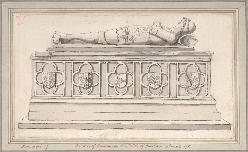
Funerary monument to Thomas de Braose in St Mary's Church, Horsham
Brambling Road
- Postcode: RH13 6AX
- Length: Approximately 280 metres long
- Connected to: St Leonard’s Road, Brambling Close, Heron Way
- Nearest Schools: Heron Way Primary School, Queen Elizabeth II Silver Jubilee School, The Forest School
- Nearest Rail Station: Horsham Station is 0.95 miles away, Littlehaven Station is 1.5 miles away
The brambling is similar in shape and size to the chaffinch. The male brambling has a black head in summer, and an orange breast with white belly. In flight it shows a long white rump. The female's summer plumage is the same as in the winter, but brighter. They are gregarious in winter, it may form flocks of many thousands and often joins with chaffinches. Numbers can vary between winters depending on food supplies. They eat seeds in the winter and insects in the summer.
Brighton Road
- Age: 1830s
- Postcode: Multiple RH13 5 and 6 postcodes
- Length: Approximately 4,973 metres long
- Connected to: Queen Street, Boxall Walk, Arthur Road, Goring’s Mead, Bedford Road, Clarence Road, Eastgate Mews, Moons Lane, Kennedy Road, Tanyard Close, Elm Grove, Arun Way, Fletchers Close, Smugglers Mews, Higgins Way, St Leonard’s Road, Hernbrook Drive, Kerves Lane, Oaklands Close, Hornbrook Copse, Sedgewick Lane, Doomsday Lane, Pound Lane, Church Road, Nuthurst Road
- Nearest Schools: Heron Way Primary School, Littlehaven Educational Trust, QE II Silver Jubilee School
- Nearest Rail Stations: Horsham Station is 1.58 miles away, Littlehaven Station is 2.27 miles away
Brighton Road has long been the route from Horsham to Brighton, as it continues to be. The first houses to be built along Brighton Road were in the 1830s, with a few still standing. One notable Horsham resident of Brighton Road was Billy Law, who as well as being an ostler to the horses at the local Kings Head Inn was the town crier. In 1912, Law won the All England Town Criers competition, up against stiff competition from forty other entrants.
Britten Close
- Postcode: RH13 6RZ
- Length: Approximately 83 metres long
- Connected to: Elgar Way
- Nearest Schools: Leechpool Primary School, Northolmes Junior School, St Robert Southwell Catholic Primary School
- Nearest Rail Station: Littlehaven Station is 0.87 miles away, Horsham Station is 1.38 miles away
Benjamin Britten was an English pianist, conductor and composer. He studied at the Royal College of Music in London, where he studied with John Ireland and Ralph Vaughan Wiliams. He is best known for his operas, especially Peter Grimes, Billy Budd and the Turn of the screw. He is also known for starting the Aldeburgh Festival in the Jubilee Hall on Crabbe Street, a few doors down from his first home, in 1948.
Brockhurst Close
- Postcode: RH12 1UY
- Length: Approximately 121 metres long
- Connected to: Hills Farm Lane, Eastcroft Mews, Fernhurst Close
- Nearest Schools: Tanbridge House School, Arunside School, St John’s Catholic Primary School
- Nearest Rail Station: Christ Hospital Station is 0.87 miles away, Horsham Station is 1.45 miles away
Broc in a place name usually means either stream or badger, and Hurst can mean either a wood or a hill, or a wooded hill. There is a William de Brokhurst, mentioned in the Subsidy Rolls of Sussex from 1296.
Bryce Close
- Age: 1970s
- Postcode: RH12 4EG and RH12 4EF
- Length: Approximately 79 metres long
- Connected to: Manor Road
- Nearest Schools: Littlehaven Infant School, Northolmes Junior School, St Robert Southwell Catholic Primary School
- Nearest Rail Stations: Littlehaven Station is 0.37 miles away, Horsham Station is 1.00 miles away
Bryce Close is named after David Bryce, who once ran a furniture store in East Street during the mid-twentieth century. Additionally, Bryce was a local councillor and was involved in many local issues. Also named after Bryce was the David Bryce Day Centre, once used by Age UK, however this was demolished in the early 2010s to make way for the building of new houses and flats.
Bunting Close
Postcode: RH13 5PA
Length: Approximately 137 metres long
Connected to: Harwood Road
Nearest Schools: Kingslea Primary School, Horsham Nursery School, Millais School
Nearest Rail Station: Horsham Station is 0.59 miles away, Littlehaven Station is 0.83 miles away
The buntings is a bird which is related to American sparrows. They are rather finch-like but have differently-structured bills, slightly flatter heads, longer bodies, and many have longer tails with white sides.
The estate was developed by a building firm called Buntings.
Burns Close
- Postcode: RH12 5PF and RH12 5PE
- Length: Approximately 192 metres long
- Connected to: Dutchells Copse
- Nearest Schools: Holbrook Primary School, All Saints CofE Primary School, North Heath Community Primary School
- Nearest Rail Station: Littlehaven Station is 0.40 miles away, Warnham Station is 0.91 miles away
Robert Burns was a Scottish poet and lyricist. He is best known for Auld Lang Syne but he wrote over three hundred songs. He is celebrated on Burns Night, the 25th January, an excuse for the drinking of whisky, and perhaps eating haggis, neeps and tatties, whilst wearing lots of tartan, if you want to experience the whole tradition.
Butlers Road
- Postcode: RH13 6AJ
- Length: Approximately 136 metres long
- Connected to: Woodland Way, Wellwood Close
- Nearest Schools: Northolmes Junior School, Leechpool Primary School, Littlehaven Infant School
- Nearest Rail Station: Littlehaven Station is 0.70 miles away, Horsham Station is 1.15 miles away
The name Butler may come from Botelers who were a noted Sussex family. There is a record of a Henricus le Boteler being a member of parliament for Horsham during the reign of Richard II, and his father John being taxed as the richest man in Horsham. A chantry in the parish church was dedicated to Henry and Mary Boteler in 1447.
Byron Close
- Postcode: RH12 5PA
- Length: Approximately 120 metres long
- Connected to: Dutchells Copse
- Nearest Schools: Holbrook Primary School, North Heath Community Primary School, All Saints CofE Primary School
- Nearest Rail Station: Littlehaven Station is 0.39 miles away, Warnham Station is 0.92 miles away
Lord Byron was a romantic poet, and friend of Percy Blysse Shelley. Shelley’s family had extensive links with Horsham, Percy being born at Field Place, Warnham. It was on a holiday in Switzerland with Lord Byron that Mary Shelley wrote Frankenstein.
Register with us
Be the first to see your perfect listings